 Catalogue PIGMA
Added-value products
Type of resources
Available actions
Topics
Keywords
Contact for the resource
Provided by
Years
Formats
Representation types
Update frequencies
status
Scale
Resolution
-
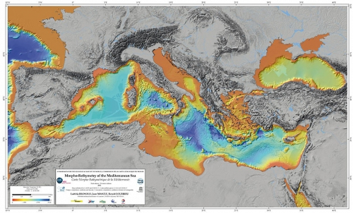
The systematic swath bathymetric mapping of the Mediterranean Sea started in the mid-nineties. This mapping has considerably modified our understanding of the morphology of the Mediterreanean Sea and of the various active geological processes (sedimentary, tectonic, volcanic, bio-geochemical processes) which participate to the seafloor morphology.
-
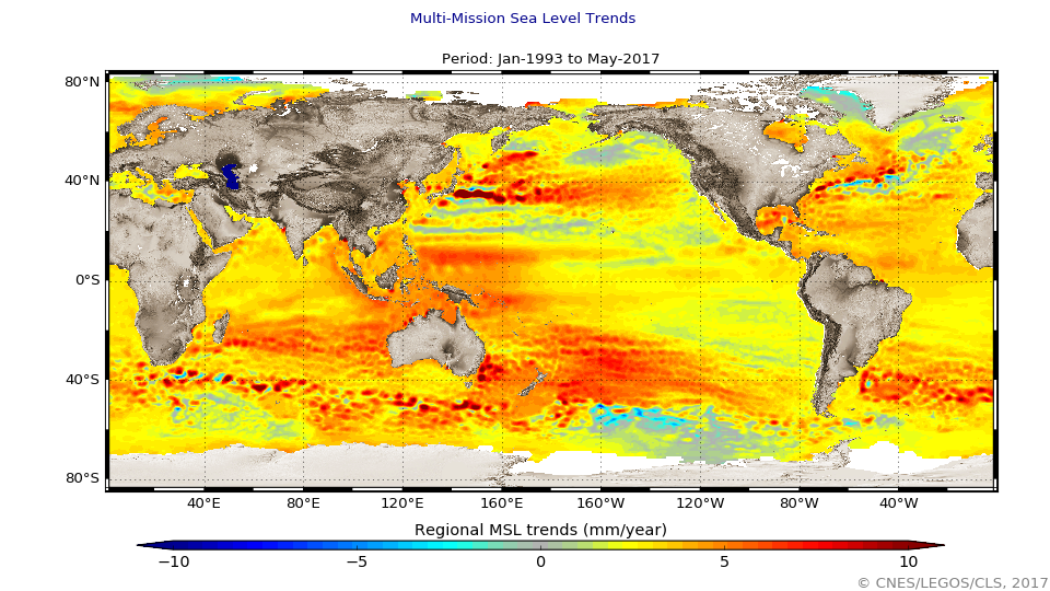
The global mean level of the oceans is one of the most important indicators of climate change. It incorporates the reactions from several different components of the climate system. Precise monitoring of changes in the mean level of the oceans, particularly through the use of altimetry satellites, is vitally important, for understanding not just the climate but also the socioeconomic consequences of any rise in sea level.
-
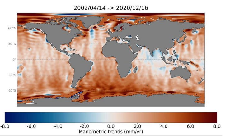
Barystatic and manometric sea level changes represent the mass component of sea level changes at global and regional scales respectively. Barystatic and manometric sea level changes are estimated here using the satellite gravimetry measurements from the GRACE and GRACE-FO missions. Two products are distributed over the April 2002 to August 2022 period: - Barystatic sea level changes from satellite gravimetry with uncertainties at 1-sigma: monthly time series, - Manometric sea level changes from satellite gravimetry with uncertainties at 1-sigma: monthly grids with 1x1 degree.
-
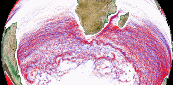
Eddies detected in Delayed-Time (DT) for the entire period [1993 - present]. Variables provided include day-by-day, and for one rotation type (Cyclonic/Anticyclonic) : - Center position (Longitude and latitude of the center of the best fit circle with the contour of maximum circum-average geostrophic speed); - Amplitude (|SSH(local_extremum) – SSH(outermost_contour)|); - Speed radius (Radius of the best fit circle with the contour of maximum circum-average geostrophic speed); - Speed average (Average geostrophic speed of the contour defining the speed radius); - Speed profile (Profile speed average values from effective contour inwards to smallest inner contour); - Effective contour (Largest contour of the detected eddy); - Speed contour (Contour of maximum circum-average geostrophic speed for the detected eddy).
-
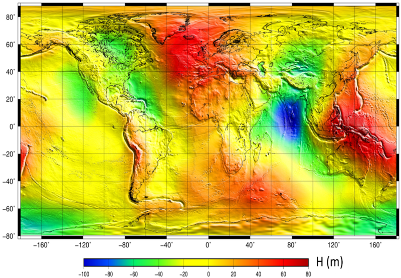
The mean sea surface (MSS) is an important field in physical oceanography, geophysics, and geodesy. In principle, it corresponds to the time-averaged height of the ocean surface. Auxiliary product : mean sea profile above a reference ellipsoid (T/P or WSG84). This surface is available on a regular grid (1/60°x1/60°, 1 minute). Another grid provides the estimation of error fields which represent the MSS accuracy estimated through the inverse technique.
-
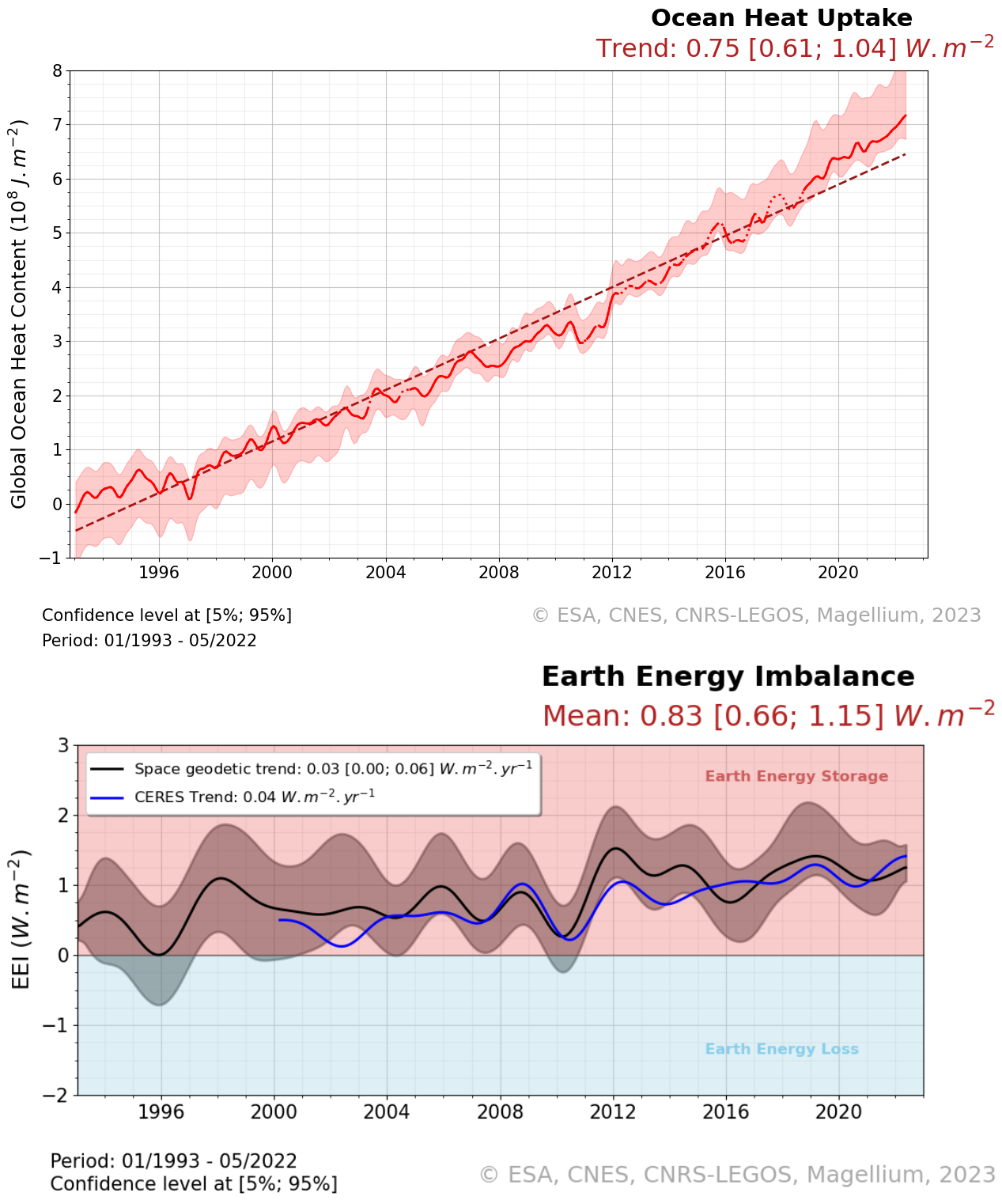
The Ocean Heat Content ("OHC") is estimated from the measurement of the thermal expansion of the ocean based on differences between the total sea-level content derived from altimetry measurements and the mass content derived from gravimetry data, noted “altimetry-gravimetry”. The Earth Energy Imbalance ("EEI") indicator is derived from the temporal variations of the ocean heat content, i.e. by calculating its derivative (called the ocean heat uptake). The product is delivered in two distinct files. The main one contains the essential variables like Global Ocean Heat Content, Earth Energy Imbalance time series and their relative variance-covariance matrices. The second file contains more variables than the first product like time series of Ocean Mass, Sea Level et Steric Sea Level change grids. It also includes additional variables that were not used for the Global ocean heat content calculation, such as the Global mean of ocean mass, Global mean sea level and Global mean steric sea level time series, but which may nevertheless be of interest to users. Users will therefore be able to find, among other things : - the regional map of the Ocean Heat Content trends (see image associated with this metadata sheet), - global ocean heat content change time series (representative of the globe within the extent of data availability), - earth energy imbalance time series (from global OHC filtered-out from signals lower than 3 years), - the uncertainties associated with these two datasets.
-
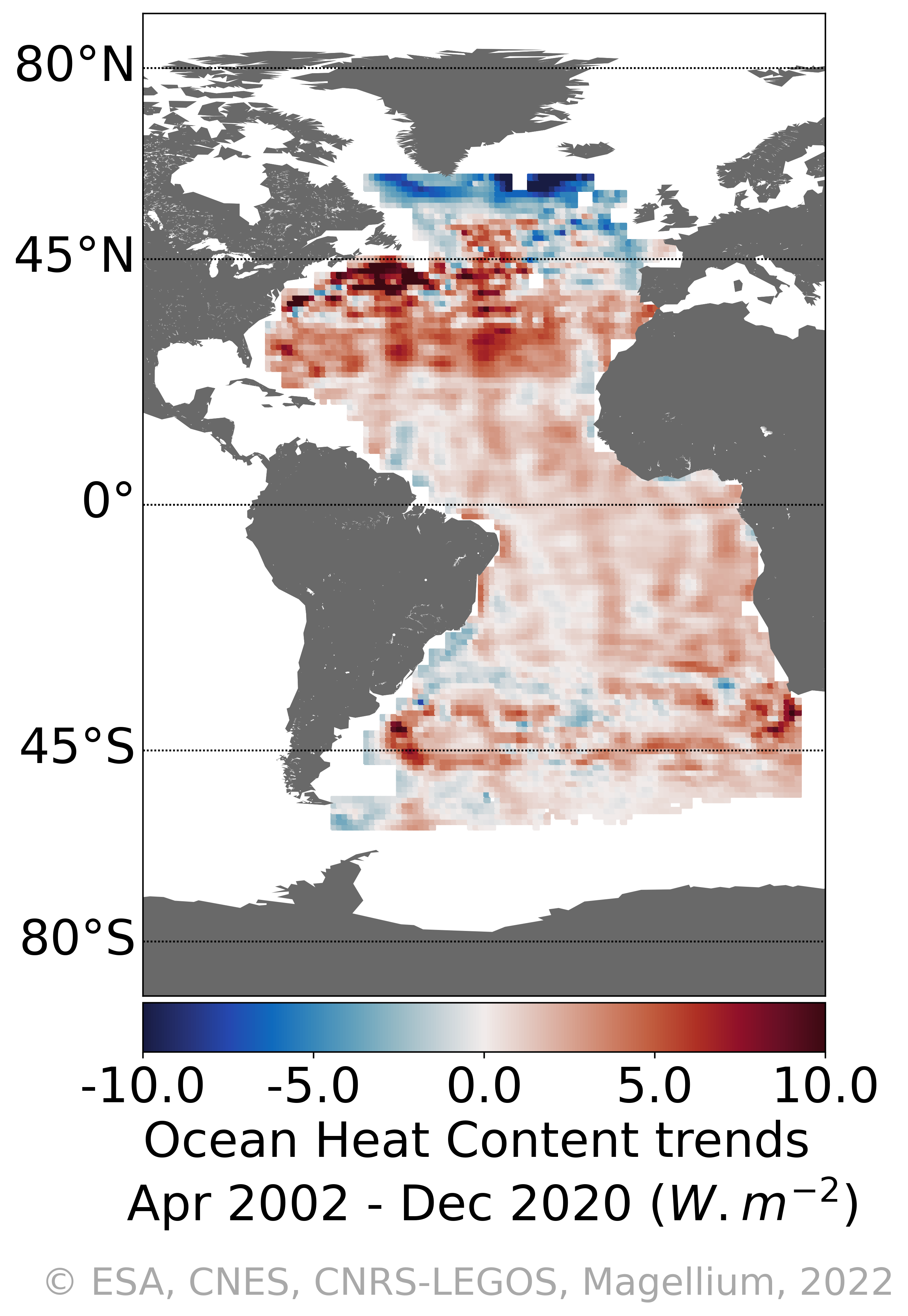
Regional heat content change over the Atlantic Ocean with the space geodetic approach : "4DAtlantic-OHC" The Ocean Heat Content ("OHC") is estimated from the measurement of the thermal expansion of the ocean based on differences between the total sea-level content derived from altimetry measurements and the mass content derived from gravimetry data, noted “altimetry-gravimetry”. Users will be mainly interested in: - Monthly gridded Atlantic Ocean heat content change - OHC trends and their uncertainties
-

Multimission altimetry-derived gridded from Ssalto/Duacs products backward-in-time Finite Size Lyapunov Exponents and Orientations of associated eigenvectors
-
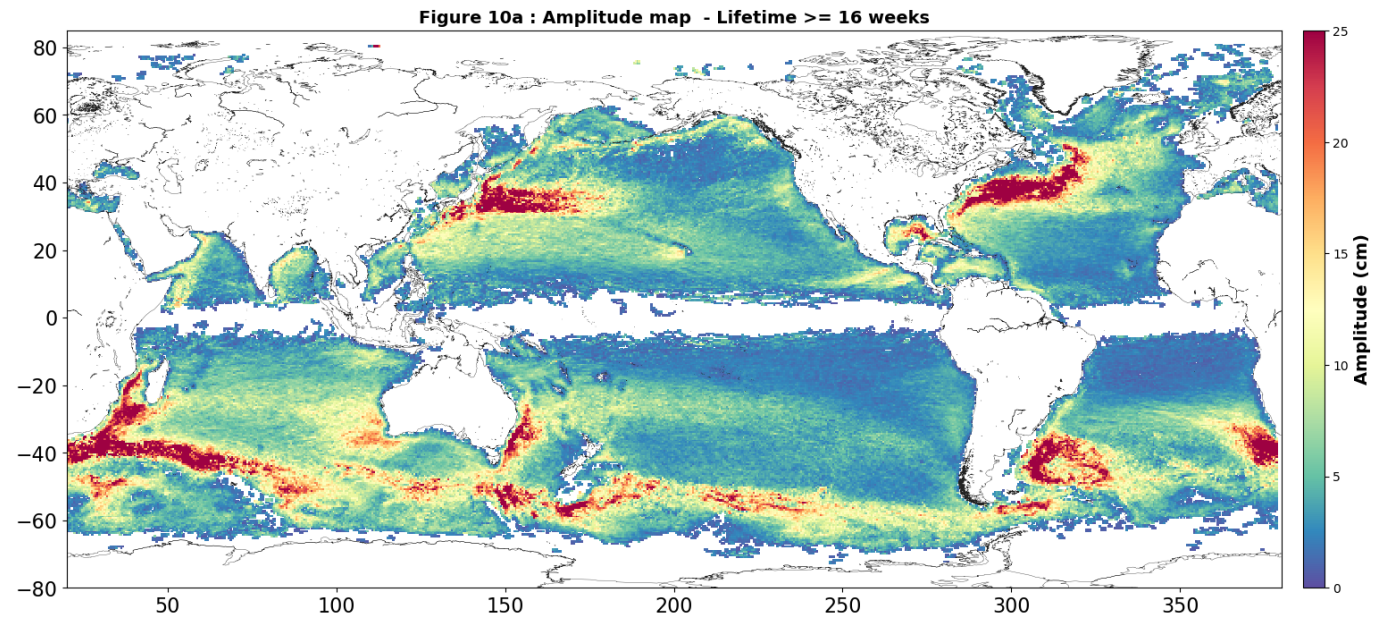
Eddies detected in Delayed-Time (DT) for the entire period [1993 - present]. Variables provided include day-by-day, and for one rotation type (Cyclonic/Anticyclonic) : - Center position (Longitude and latitude of the center of the best fit circle with the contour of maximum circum-average geostrophic speed); - Amplitude (|SSH(local_extremum) – SSH(outermost_contour)|); - Speed radius (Radius of the best fit circle with the contour of maximum circum-average geostrophic speed); - Speed average (Average geostrophic speed of the contour defining the speed radius); - Speed profile (Profile speed average values from effective contour inwards to smallest inner contour); - Effective contour (Largest contour of the detected eddy); - Speed contour (Contour of maximum circum-average geostrophic speed for the detected eddy).
-
Auxiliary products